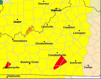
Areas in yellow signify a tornado watch. Photo courtesy of the National Weather Service.
By MICHAEL CRIMMINS
Glasgow News 1
Barren County, and much of the western portion of the commonwealth, is under a tornado watch, according to the National Weather Service out of Louisville.
The watch — which means “weather conditions could lead to the formation of severe storms” — is in effect for Barren County until 11 p.m.
In addition to the watch, Barren County is also under a “hazardous weather outlook” that forecasts “strong to severe storms [that] will impact the region through the early overnight hours.”
“Several of these storms will be capable of producing tornadoes,” the NWS states. “Additionally, locally heavy rainfall and damaging straight line winds will be possible.”
This is likely residual weather activity from Hurricane Beryl that made landfall near Matagorda, Texas, around 4 a.m. on Monday. Beryl left thousands of Texans without power and, as of the time of publication, has killed at least six people.
This article will be updated should new weather-related information become available.

Comments