
By MICHAEL CRIMMINS
Glasgow News 1
Updated as of 3 p.m. May 8
A severe thunderstorm watch has been issued for Glasgow, KY and surrounding areas.
According to the National Weather Service, there’s an 80% chance of precipitation nearing 4 p.m. and a 100% chance of rain closer to 11 p.m.
This watch indicates that weather conditions could lead to the formation of severe storms that produce high winds. Residents should stay informed and be prepared for changing conditions.
Please exercise caution and follow any safety advisories issued by local authorities
Updated as of 1:42 p.m. May 8
The National Weather Service in Louisville has issued tornado watch for Barren County in addition to the ongoing flood watch currently in place.
The watch is in effect until May 8 at 9 p.m. The surrounding counties are also under the watch including Warren, Allen, Metcalfe, Hart, Edmonson and Monroe Counties.
— — —
The National Weather Service in Louisville has issued a flood watch for all of Kentucky — save the western most tip of the commonwealth, which is under a tornado watch.
The watch is in effect until May 9 at 7 a.m. CDT. All of the counties surrounding Barren are under the same flood watch.
“Excessive runoff may result in flooding of rivers, creeks, streams, and other low-lying and flood-prone locations,” the watch states. “You should monitor later forecasts and be alert for possible Flood Warnings. Those living in areas prone to flooding should be prepared to take action should flooding develop.”
This watch comes as the NWS puts Barren County under a “hazardous weather outlook” stating that “multiple rounds of strong to severe storms are possible today and tonight. Damaging straight line winds, large hail, and tornadoes will be possible with severe storms.”
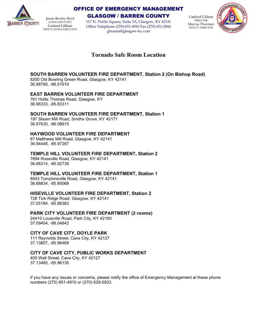
As a reminder there are ten tornado safe rooms throughout Barren County. They are:
This article will be updated should additional weather information become available.
Comments